Picking the best weather window
We woke up before dawn on December 10 and immediately checked the wind and sea state forecast to decide if we would cross the Gulf Stream to the Bahamas. It wasn’t ideal, but it wasn’t terrible. We needed to be in Hope Town by December 19th to meet the Swedish side of the family so we also knew we didn’t have time to wait around for the perfect forecast. There is a common cruising adage that says you should never sail by a calendar. That’s all well and good if you’re independently wealthy or retired or have no commitments other than yourself and your sailboat, but since we have to plan around Hans’s work schedule, we are basically always sailing by the calendar. Granted, we plan ahead and build in lots of extra days to wait for good weather, but sometimes we have to take the “good enough” forecast.
We decided that the pre-dawn Gulf Stream crossing forecast was good enough. The forecast: winds around 15 knots from the north with 2 meter seas with a 12 second period. I’ve heard more than once that you should never try to cross the Gulf Stream from Florida to the Bahamas when there is any north in the wind. Why? The Gulf Stream flows from south to north at upwards of 3.5 knots, so a north wind against that strong southerly current has the potential to create messy, uncomfortable, and possibly dangerous conditions. But we felt that 15 knots of wind isn’t too windy and a 12 second period meant that the waves wouldn’t be steep. We didn’t feel 100% confident in the forecast or what the sea state would actually be like, so we decided to just go out the inlet see how it felt. If it got too rough we could always turn back or sail south to the West Palm inlet.
Sticking our noses out
It’s hard to not have a solid yes or no with weather and passage-planning, but sticking your nose out and having a plan b, c, and even d is a solid strategy when the forecast isn’t clear. The biggest challenge with the “sticking your nose out” strategy is that it is often psychologically hard to bail once you’re started a passage. Once you’re out there, sailing along, it’s tempting to just keep going, even if it gets really rough and uncomfortable. After all, you’re provisioned, you woke up early, and everything is stowed. It’s a lot of work to weigh anchor and push off. Knowing that, we explicitly stated that we were willing to turn back if necessary, so I felt confident in our plan as we weighed anchor at sunrise.
It turned out to be a fine passage. Motorsailing out the inlet was lumpy, as basically every inlet and harbor entrance is, but the sea settled down once we got a few more miles off the coast. We decided to keep going. It was time to look more closely at the chart and do some route planning. Picture trying to cross a river with a strong current. If you aim for a point directly across the river, you’ll end up further downstream. So start fording the river further upstream, cross perpendicular to the current and the current will pull you along to your desired point. There’s some logic, a lot of math, and quite a few adjustments along the way. Since we were leaving from Ft. Pierce—a little north of the entrance to the Little Bahama Bank—we sailed south for about 20 miles before turning east. We wanted to cross the Gulf Stream at point south of our destination to allow the current to set us north. We roughly calculated that the current would pull us 10 miles north during the 6 hour sail across the stream, landing us, hopefully, at the northern most entrance to the Little Bahama Bank.
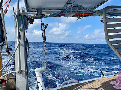
It definitely got lumpy and bumpy in the middle of the Gulf Stream, but it was a beautiful sunny day and we felt secure on PW. We all found semi-comfortable places to wedge ourselves and listened to audiobooks, fished (Hans, unsuccessfully), and watched for birds, dolphins, and turtles. When we got out of the worst of the current it was clear that, at our current speed, we would end up north of our waypoint. I turned the engine on and we motorsailed for about 10 miles to get more speed up to get us across the current more quickly.
 |
Not a fish, just a gigantic lure. Hans's Gulf Stream fishing ambitions were high.
|
 |
Sailing along. It definitely got calmer as we got to the other side of the stream
|
Just a mile off the Banks, the depth came up rapidly—it’s a massive cliff from the edge of the Banks into the Gulf Stream and it’s pretty dramatic to see. Unfortunately we arrived right at sunset so we couldn’t see the bottom come up by looking in the water, but it we saw how steep it was on the depth sounder.
As soon as we got on the Banks and started getting protection from the northernmost reefs of the Abacos, the sea state settled down. We lost all the swells and were only getting wind chop. Unfortunately the wind also died down so we had to turn the engine back on around 9PM and we ended up motoring the rest of the way to Green Turtle Cay. I did have the engine off for a few hours in the early morning hours of my watch but our speed gradually decreased from 6 knots to 4.5 knots to under 4 knots. Time to fire up the engine again!
 |
Good morning Bahamas!
|
 |
Land ho! And Matilda on the bow looking for starfish on the bottom.
Crystal clear in 4-6 meters of water.
|
Back in the Bahamas!
We arrived at Green Turtle Cay just before 11AM, about 28 hours after we left Ft. Pierce and, by sheer luck, the same time the customs and immigration official arrived at Green Turtle Cay. Hans jumped in the dinghy with our paperwork and the kids and I jumped in the crystal clear water, thrilled to be swimming in tropical again.
We spent the next few days in Green Turtle Cay, enjoying our first Bahamian anchorage, eating conch fritters, walking to the beach, and finishing up our last week of school before Christmas break. It is definitely the winter season in the Abacos with frequent cold fronts that bring squally weather for 24 hours and then stronger north winds for a few days. It’s not tropical warm, but it’s in the mid-70s most days and cooler at night. Wetsuits are a good idea for any extended snorkeling and it’s nice to have a sweater at night. No one is complaining about the weather!
 |
Exploring Green Turtle Cay.
The pic is very reminiscent of one from Bermuda--boat kids on land again!
|
 |
Green Turtle's windward beach. These islands are close enough to Florida to make them pretty easy for most Americans (with $$) to visit, but small enough and remote enough that there is no mass tourism on the out islands. The beaches are usually always empty.
|
 |
A little too chilly for swimming.
|
 |
The kids enjoying the swings that hover just over the crystal clear water.
|
 |
Sunset at Green Turtle Cay.
|


Comments
Post a Comment